By Brian Hoop
As this newsletter issue goes to production, neighborhood leaders anxiously await the removal of locked gates to a new pedestrian path at NW 107th Ave. that will provide the first public close-up river view on the lower Willamette River’s west side in several generations.
While there is much to celebrate with the opening of this long-anticipated pathway to a river overlook, it is only half the battle towards eventual access to the river’s edge. There is renewed interest in City land use maps designating a future trail along the riverbank to the North at the high-water line as part of the Willamette Greenway Plan approved back in 1988. Unfortunately, eventual public access to a rare sandy beach along the river may be deferred for another generation.
When does the pathway open up?
TV station KGW got peoples’ hopes up with a story on June 2 indicating gates to the pathway would be open within days. See story at https://tinyurl.com/fsepxuxn. Turns out the story was premature as installation of benches and signage are delaying final City permit approvals. But oh, how delightful the field of Lupin flowers were to many a passerby during their short duration beyond the chain link fence where once stood the mighty Linnton Plywood Mill.
Development of the public path, which was advocated for by the Linnton Neighborhood Association, is one piece of the $10-million-plus habitat development company RestorCap. The natural habitat mitigation project was paid for by industrial companies needing to settle liabilities for the damage they did to the river ecosystem over the past 100+ years.
A representative for RestorCap indicated they will not remove the temporary fence until they pass final inspection. Neighborhood leaders hope to have a simple celebration recognizing the occasion this summer.
Willamette Greenway Trail and future access
down to the river
The Willamette Greenway Plan was approved by City Council in 1988 with the goal “to protect, conserve, maintain, and enhance the scenic, natural, historical, economic, and recreational qualities of lands along the Willamette River.” A key objective was to “increase public access to and along the Willamette River” including a continuous recreational trail extending the full length on both sides of the Willamette River, though not necessarily adjacent to the river for the entire length.
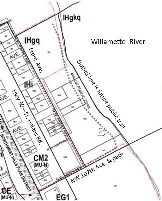
The Greenway Trail designation was applied to this site North of 107th Ave. as it was one of the only undeveloped properties along the riverfront. But this would only be aspirational as actual construction of a trail would not be triggered until significant re-development occurs.
A step was made in that direction when two land use reviews were completed on the site in 1998. The property owner, Babcock Land Company, was grading and gravelling the site for its current use as a railroad track storage yard. The company agreed to a 25’ easement and reseeded the area to satisfy the purpose and intent of the code’s “public recreational trail standards.”
However, according to Jeff Caudill, a Planner with the Bureau of Planning and Sustainability, “The dedication of an easement to the City does not require the property owner to allow public access to the easement area. Only once a trail has been formally approved and constructed, then public access would be allowed during specified hours of the day.”
No storage of material is allowed in that 25-foot setback from the top of the bank. Violations can be reported to the Bureau of Development Services at codec@portlandoregon.gov or by calling 503-823-2633.
Until that time future development might trigger construction of a trail, the public can enjoy a soon to be opened path to a river viewpoint parallel NW 107th but are barred from venturing north or south as both remain private property.