by Ryan Bukstein
It’s a beautiful Friday in Portland in December. The sky is clear and I can see Hood, Adams, St Helens, and Rainer shining in the horizon. My eyes tell me the air is clear but my air quality monitor gives a different story. I’m about to jump on my bike and ride Highway 30 and through Linnton to take samples of the air. But let’s take a step back. I’ll tell you how I got here and why I’m about to take this ride.
I moved back to Portland from LA when the pandemic hit. My wife and I want to be closer to family and have a better situation to make it through the next few years of this public health crisis. We picked a condo in Glen Harbor on Germantown Road. We moved in sight unseen but fell in love with the view in the pictures we saw. As soon as I walked in and went to my deck, it hit me. The view was incredible– the mountains, the river. But, you could feel and smell the air pollution.
This sent me down a rabbit hole of cheap air quality monitors, sleepless nights and internet searches. I finally came on a report about our area that scared me even more, but it also gave me a contact to follow up with. I contacted Greg Bourget of Portland Clean Air and Nancy Hiser, co-chair of LNA’s Environmental Committee, and learned that diesel particulate pollution is a dangerous carcinogen and poses many health problems. They were among those who are doing something about it. So, I decided to get involved.
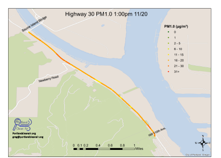
Publicly available maps have previously been based on modeling studies; they portray educated guesses–and don’t reflect collected particulate monitor data. Now, however, maps of diesel particulate concentrations in Portland neighborhoods using collected data are possible. By collecting data in one day within an ideal time window, an accurate depiction of particulate data can be measured and this allows for comparisons over time. Attaching a diesel particulate monitor (a 2019 LNA donation) to my bike with zip ties, I captured thousands of samples in my hour-long test ride along Hwy 30 between 112th St and the Sauvie Island Bridge. This information included the exact locations of the samples and the particulate concentrations. A GIS specialist, paid for by a second LNA donation, plotted this and the resulting map.
Ideally, this process should be repeated in different seasons for comparison, so I will be doing more rides along Hwy 30 in the future, including residential streets in Springville, Glen Harbor, Hoge, Linnton Hill, Harborton, and Newberry.
It’s a scary time when it comes to the destruction of our environment and the high cost of health that we exchange for our modern lifestyle. At times it feels so daunting that we don’t know where to start. I think we can start in our own backyard. Seeing visual evidence of air pollution is compelling. If we push Portland’s polluters to clean up their act, we can create precedents and processes that other cities can use. Every step (or ride) we take will be closer to healing our air.